The Amazon Outdoor Store
Any questions write: The Dick E. Bird News, P.O. Box 377, Acme, MI 49610 or email: dickebird@gmail.com
The Dick E. Bird News/Backpackingboomer.com is a bimonthly tabloid print copy that goes out to 10,000 bird watchers, hikers, backpackers, seniors and people looking for punderful news. You can see a good example of it here on the web by following the bloglinks.
The Continental Divide National Scenic Trail begins in Antelope Wells, New Mexico. I began on April 29, 1999. The following is a brief account of what I experienced..
April 29th to May 4th Left Antelope Wells, NM at noon April 29th. Road walked 11 miles then jumped the fence and headed west to the Divide. I was warned about Gray Ranch property, snakes and drug dealers. All I saw for the first 127 miles was jack rabbits, mule deer, antelope, and smelly Javelina. Plenty of water. Only had to road walk a total of 15 miles. Desert walking is more enjoyable and easier. Saw one person, a rancher that didn't speak English. Two days of 50 mph winds from the west. Had to rope my hat on. Very enjoyable stretch. Four blisters. Leave Silver City noon May 6th. Tune in next week for more of the adventure.
May 6th to May 13th The Gila NF and Aldo Leopold Wilderness were rough terrain. Little water. Very dry year. Even the springs were mostly dry. detoured into the Membres river for water. 20 miles between Reeds peak and Turkey Creek was all old burn, hundreds of blowdowns to climb over which also made route finding extremely difficult. Trail poorly marked through most of the Gila. Cut northwest across the Adobe ranch and the Plains of St. Augustine the largest ranch in Catron county. Ranchers were all friendly. Water a big problem. One day had to pump water from an abandon hunting camp tank with dead flies in it. Glad to have the pump, needed the water. Mostly found water at windmills. Had to bushwhack several times when trail disappeared. Hiked from Horse Springs north
 to Pie Town on gravel road.Ran into Bob Sundown in Pie Town. He has passed away since this trek but he was a Pie Town local icon. Halfway through New Mexico. Trip going well. Lack of water and route finding made this leg difficult but a very beautiful area. Have run into 3 other thru hikers--Leslie, Laura and Andy. Have hiked with Andy Quinn from Lakeland, Fla. four days. We all recouped in Pie Town leaving on the 14th. I leave on the 15th but will probably catch up with them. I get up earlier and hike later. More next week.
May 14th to May 23rd From Pie Town, N.M., to Cuba you could almost drive the whole distance on jeep roads and see as much as walking it. It is remote country on unimproved two-tracks, Forest Service roads and BLM roads but it is still road walking. The only section that was trail was the spur T77 that went to the summit of Mt. Taylor, the highest along the proposed N.Mex. route, 11,400+. Water has been a constant problem. Many days hiking dehydrated to some degree. From Pie Town I went north to El Malpais Wilderness. I should have stayed on the Seven Crater Scenic Byway but decided the Wilderness Area looked more interesting. My maps showed trails. I finally ended up on game trails and had to bushwhack 12 miles NW to find the Byway again. This took most of one day as the country was lava fields, crater pockets, deep crevices and very abrasive lava outcropping. I finally found the Byway again but had been out of water for most of the day. Trail Magic--A couple from Penn. stopped and gave me a quart of water. Not five minutes later a couple, the Ott's, from Austin, Tex., stopped and gave me a gallon. I did not find another water source all the way to Grants, which took another full day. I have only had to walk about 19 miles of pavement the whole route through N. Mex. but the dirt and gravel roads have still been hard on my feet. Many blisters and numb toes on both feet. Switched boots in Pie Town but still walked through a lot of pain into Grants. I usually wear a size 10 1/2. In Grants I went to Walmart and bought the softest size 12 boot I could find. From there to Cuba I have worn two pair of smartwool socks and my feet are improving daily. After a shower in Grants and a big breakfast I started toward Mt. Taylor. The Forest Service office in Grants
 had as much information about the land they manage as all the rest I had been in--ZIP! I don't think they ever get out of the office. They know nothing about water availability, trail routing, trail conditions or much else for that matter. The Nat. Forest roads are poorly marked and many do not exist that are on the outdated maps. Route finding has been a problem but I have always been able to correct without going more than a few miles out of the way. At the base of Mt. Taylor I found Trail 77 just at night fall. I sat by the sign trying to figure out where a nearby spring was supposed to be located. I had been out of water half the day. After not seeing anyone all day I heard a car with no muffler coming up the grade. It was four local Indians with a case of beer between them. I asked them if they knew where I could find water. They said there would be none in this area. The whole area is dry this year. They offered me a beer. I know you should not drink beer when dehydrated but it was after my cocktail hour and I thought it might help me sleep better with sore feet. I camped on the trail that night a hundreds yrds. off the road. In the morning, thanks to Jim Wolf's Northern N. Mex. guide I found a spring another mile up the trail. I had breakfast at the summit of Mt. Taylor. The register at the top informed me that Andy was a couple days ahead of me and Laura and Leslie were exactly 24 hrs. ahead. I walked the rest of the day trying to get out of Cibola Nat. Forest but one unmarked, washed out road threw me off track for an hour. I left Cibola the next day very thirsty and again the Wolf guide saved my bacon. It described a spring I would have never found without it. It is a southbound guide so I am reading it backwards. For me the guide fell apart south of Cuba. It described a 26 mile dry route to the SW of Cuba. The country became a labyrinth of unmarked roads and the guide did little to sort them out. I walked about 10 miles into this mess before realizing I was out of water and not on the right track. Trail Magic-- After not seeing anyone for two days and not expecting anyone out in this beautiful, yet barren backcountry, come Jim and Molly. They were part of a hot air balloon group that had planned to fly that Saturday morning. The wind would not allow so they were heading home. All I asked God for was a little water and he sent me Jim and Molly with Smoked Salmon from Pikes Market in Seattle, three kinds of beer, Pita bread, cherry tomatoes, coke, and yes, even water. If not for the high winds they would have flown me to Cuba. Rained on me all the way into Cuba but felt good after a very dry and windy month of walking. Colorado bound this week.
May 24th to June 3rd Gaila, Maggie and two friends that came out to travel with them met me in Cuba. We had a great time and found a wonderful Mexican restaurant. I left on Monday morning and headed up into the San Pedro Wilderness. New Mexico is a land of contrast. I could hardly find enough water through most of the state until I reached Cuba. After Cuba I couldn't get out of it. The San Pedro was one of the most beautiful sections of my New Mexico route and one of the most miserable. First, I had the flu or some bad food in Cuba. Second, I had 36 hours of sleet and lightning. I did not carry rain gear because I felt I wouldn't need it until Colorado. I did have my umbrella that saved me from real misery. The Wolf guide that did help in some sections had a mistake coming out of the San Pedro that cost me 10 miles on a day I didn't need any additional miles. I started into the Chama valley but my gear was completely wet and I was freezing. I decided I would backtrack out to Hwy. 96 and hitch a ride all the way back to Cuba. That sounded good but Hwy. 96 had very little traffic. I rancher picked me up and took me a few miles to a road junction he said would give me a better chance of a ride. It was getting dark and I was in a pair of shorts, the only thing I had left that was dry. The rancher was right, about an hour later another truck went by. It was a young man and his girl friend. I was so cold I offered them twenty bucks to take me into Cuba. He didn't have a license on his truck or he said he would. They left but returned in about 20 minutes. They said I looked real cold. They couldn't take me into Cuba but he said I could stay at their place. They lived with her parents in the little town of Regina. So into Derrick Shipley's truck I jumped. It had a wonderful heater. We first had to go out through the Jicarilla Indian Reservation to get to his dad's place to get his paycheck. We had to stay off the main roads because of the license problem. As it turned out Derrick's dad was the guy who had dropped me at the intersection earlier in the evening. We finally made it to George and Lynn Lathams house where Derrick and Patty lived. They fed me and let me warm up next to the woodstove. After awhile Derrick said, "You don't play the guitar any do ya?" I said, "Bring that thing over here." I was in my glory. Derrick had a 12 string with six good strings on it. I had a captive audience and played them every song I have ever written. Derrick is just learning to play and loves to write songs. I showed him a few licks and told him to hang in there. Not much work in this part of the country. Derrick was testing for his CDL
 license so he could work on a big highway expansion job beginning soon in the area. George had been a log skidder, truck driver, bar owner and all around jack of all trades. Wonderful people who would take a wet, smelly stranger off the highway and offer him what little they had. The next morning it was back out to 96 and try to get back on the trail. Much of my gear was still damp, I still had the flu and my goal was to get to Ghost Ranch as soon as possible. I walked up the road for two hours until an older gentleman stopped and said, "I'll give you a ride if you don't have a pistol." I said, "I'm carrying a lot of things, but a pistol isn't one of them." He took me as far as the Post Office in Gallina. I began to walk again and another young man by the name of Chris Branch picked me up. He was 15, but seemed much older. He was a bull rider and had many injuries to show for it. He told me he could take me where I needed to go but first we had to pick up a gooseneck cattle trailer in Coyote. I told him I would be glad to help him do anything if he could get me back to where I left off the trail. Late that day I made it all the way into Ghost Ranch. I had been dreaming of a hot shower. I couldn't seem to get warm and I felt dehydrated. My boots and much of my other gear was caked with red New Mexico mud. The weather was continually wet. The many painters that come to Ghost Ranch were disappointed in the abnormally wet conditions. Gaila and Maggie came to Ghost Ranch and I took a day off to recover. They doctored me and tried to get me back to my usual healthy state. Andy Quinn and Laura and Leslie were a couple days ahead on the trail. They had been through the Ranch just before I arrived. I had not seen any of them since Pie Town, N.M. I decided I would road walk Hwy 84 from Ghost Ranch to Cumbress Pass about 60 miles. I had only road walked about 20 miles of New Mexico up until this point but I was feeling very weak and didn't want to deal with the mud and rain for a few days. I made it to Chama, New, Mexico in two days and up to Cubress Pass, CO by May 30th. On Memorial Day I was back on the pass and headed for Pagos
 a Springs. We had found Laura and Leslie. They were staying with Gaila and Maggie. They had to wait for the Post Office to open after the holiday to get their next food drop. Figured Andy must be a few days ahead. I was mistakenly thinking the CDT would be better marked in Colorado. At Cubress Pass I found a CDT sign at trail 813. I followed it for a full day without ever seeing another sign of any type. I had been following the snow conditions in Colorado all winter. It seemed like the perfect year to go south to north. What I didn't expect was the huge volume of spring snow. From Cumbress I began postholing into snow up to my waist. I would have to wade through snow to reach Wolf Creek then wade through more snow climbing out. Each shaded valley section of trail became a nightmare of punching through the deep snow. When I finally made six miles the trail disappeared into a forested section of deep snow. I spent an hour looking for trail but decided I needed to retreat and get my snowshoes. I made it back to Cubress Pass the next morning and sat on the road enjoying the warm morning sun. I guy stopped and asked if I needed a ride to Chama. His name was James Cotton, the definition of "FREE." He lived on axles. His truck mostly. He is writing the Encyclopedic Volume of the word "FREE." It should be out next year. Interesting guy. I talked to James for quite awhile at the gas station in Chama where he stopped to gas up and recharge his laptop. I was feeling defeated by the trail as I turned and started up the road through town. In an instant my whole attitude changed. Coming up the road toward me was Andy. He had been to the pass twice already. After his first attempt he came down, hitched all the way to Pagosa Springs, bought snowshoes and came back. After postholing even with snowshoes he came back down and worked on a alternate route. He was headed back up the mountain. We then ran into the girls. Gaila and Maggie were taking Laura and Leslie back to the pass. We told them what we had found and they were going to try an alternate route that looked as precarious as those Andy and I had already attempted. Andy and I stopped for breakfast and decided to hike together up a lower route and take our snowshoes for the passes. It seemed like a great plan the first day heading up FR 250. The weather was perfect and the scenery was calendar quality. The second day we hit deep snow at about 11,000 feet. Elwood pass was completely covered, socked in with snow and lighte
 ning all around us. We were again postholing even with our snowshoes on in the wet snow.We had a little problem finding the road as it came off the pass but finally found it above us. We hiked late into the evening trying to get to lower elevation and a dry area to camp. After a damp night we made it to hwy. 160 and Gaila and Maggie met us with Charlie, a guy they were camped near in Pagosa Springs who had a jeep.
June 4th-June12 Still a lot of snow on the Divide. Every time we try to get back on top we posthole in the soft snow and progress is very slow. After a day in Pagosa Springs we went back to Wolf Creek pass and began road walking in a snowstorm toward South Fork, CO. and then north to Creede. Wolf Creek pass had four inches that day. We slept that night in a canyon next to the Rio Grande River and woke up to the coldest morning yet. By mid-morning Andy and I ran into Laura and Leslie coming off a trail that intersected Hwy 194. We all walked into Creede together. Our first stop was San Juan Outfitters who gave us some trail info. They suggested trail 804 west to Spring Creek Pass. It went straight up. L&L and Andy ate those steep miles right up. I on the other hand huffed and puffed all the way. Occasionally I would just lay down in the middle of the trail and suck in as much Colorado oxygen as possible. We camped near the top in a beautiful stand of Aspen. The next morning we started into switchbacks that were a bit kinder to me but still I would find a little morning sun on the trail, lay down in it and wait for my heart to pump enough blood to my brain to help it convince my feet to begin climbing again. When I reached the top Andy was waiting on the side of a frozen drainage and the girls had moved on. We scooped enough water to make breakfast and then immediately lost the trail in the heavy snow. We spread out and finally found the trail an hour later on a slope north of us. It would meander in and out of snowbanks as a trail, a jeep track, dirt road and a grassy tread. The biggest challenge of the CDT and its many proposed and alternate routes is route finding. We started up again into deep hard packed snow that soon turned to mush and again we were postholing to our waist. It was only a couple miles of continuous snow and we began dropping to lower elevation. Not being able to stay up on the Divide has not taken anything away from the trip. Our alternate routes are backcountry, beautiful and full of Colorado spring colors. Water crossings are sometimes challenging. The water is so cold you can chew it and when it gets up to my temperature control modules it can be very painful but I was concentrating on not letting the volume knock me over. From Spring Creek Pass we hitched into Lake City to pick up resupply packages, eat pizza and take a shower. We camped at Bob and Jacque Carey Lake City Campground. Great folks. L&L were already there. The next morning Bob gave all of us a ride back to the pass which was 20 miles straight up. We dropped to lower elevation and hiked a valley northeast between the La Garita Wilderness and the Powerhorn Primitive Area. After two days the girls decided to try the Divide again at Cochetopa Pass. Andy and I continued on at lower elevation and took a BLM road toward Doyleville south of Gunnison. We arrived in Doyleville at dusk and decided to hitch to a little General Store six mile up the road. When we arrived the store was open but I have no idea why. The most nutritious thing we could find was GatorAid and Eskimo Pie. Since I have decided to write a CDT guide on the best Mexican Restaurants along the trail and Gunnison was now only 13 miles away we decided to hitch into Gunnison. Being total optimists we figured we could hitch in, eat and still hitch back to the trail by dark. It was getting cold and dark and no one seemed to find us potential riders. I was looking at traffic coming from the opposite direction and suggested to Andy we cross the road and hitch back to the trail. I saw a motorhome coming that looked a lot like mine. It was even pulling a little Saturn behind it. It even had a poster of my book on the side of it. Gaila and Maggie who should have been in Mesa Verde NP or Black Canyon of the Gunnison had gotten ahead of schedule and were heading for Monarch Pass to meet up with us. They saw us and were equally surprised. We loaded our gear in and headed back for Gunnison. We made a pit stop at the Blue Iguana Mexican food restaurant and had a wonderful Chimichunga. The next morning Gaila dropped us at the trailhead and we started off toward Old Monarch Pass. The weather has been warm and the Divide is losing a lot of snow. Deciding not to flipflop north and just hike Colorado at lower elevation has been a great decision. It is incredible country and very enjoyable backpacking. My thirty year-old pack has finally been retired. It lasted the first 1,000 miles but I was keeping it together with ductape and safety pins. Jansport was kind enough to ship me, overnight, a new pack at a very reasonable price. I have started using the zero degree down bag that EMS sponsored me with and the Magellan satellite communicator has been a great device for staying in touch with my family. They have been having a wonder adventure of their own and I don't have to worry about them waiting on the side of the road wondering where I am. Another great piece of equipment given to me by EMS is the Magellan Blazer 12 GPS. It is so quick and easy to use I keep it right in my pocket to check w
 aypoints when bushwhacking or looking for trail in snow covered passes.
June 13th to June 20th From Monarch Pass I began following the Colorado Trail. At times the Colorado Trail and the Continental Divide Trail are the same. The CT is usually at lower elevation than the CDT. Even at the lower elevation the CT has been difficult to maneuver with all the spring snow that Colorado received. Route finding is often difficult when the snow gets deep on the north facing slopes. Many sections have not been maintained this early in the season and besides snow blocking the trail winter blowdown has me climbing over hundreds of trees across the trail. The snow on the north slopes is soft which turns out to be a blessing. I am not carrying an ice axe and the soft snow lets me sink in and self arrest my descent. I lost the trail in a snowstorm at a trail junction called Frenchmen's Creek. It was not on my map. I postholed through snow for about four miles before I realized my mistake. I dreaded the thought of going back through the snow so I slept that night at the base of Mt. Harvard in the Collegiate Peaks Wilderness. The next morning I bushwhacked straight up over a very steep ridge and found the trail again after six hours of climbing. If the CDT or CT is anything it is a route finding challenge during spring snow cover. I am beginning to run into other backpackers on sections of the trail and many local mountain bikers. The bikers are limited to lower elevations. At ten to twelve thousand feet there is just too much snow for them to deal with. I spent Father's Day making my way to Tennessee Pass just outside of Leadville, Colorado. From Galena Mountain to Longs Gulch I spent four hours in knee deep snow working my way down into the valley. Laura and Leslie are a day ahead of me and I could often see their tracks as they worked their way through this labyrinth of snow covered trail. My shoulder often pops out of joint. I found a great way to put it back. I fell face down in a creek but caught myself with my hands finding myself in a push-up position in the middle of a cold, rushing Colorado spillway. The force of my pack shoved my shoulder back in place. I could hear it pop. I am not sure I recommend this procedure but it did work for me. This section has been very rainy but beautiful. I took a day off at Twin Lakes and went to Aspen and Glenwood Springs. Maggie, Gaila and I checked out the passes and the CDT in many places and found it snow covered. At Tennessee Pass there is a memorial to the 10th Mountain Division who did many heroic things during WWII. It was Bob Doles outfit. Many of the men in the 10th came back to Colorado after the war and started ski areas around the state. My vision of the CDT has changed drastically since I started hiking this trail almost two months ago. Even though it is impossible to stay up on the Divide itself this early in the spring there are a number of alternate routes that are spectacular and challenging. The country I am walking through is Calendar perfect and isolated from all but the earliest hikers. Between the rain and snow there are glorious sunny portions of the day when you can see forever. The temperatures are actually quite mild and the Aspen are all leafing out except at the highest elevations. The ptarmigan are turning their summer molt and the grouse are strutting their stuff. The trail has been full of wildlife since the very beginning. My new Jansport Alaskan pack is working out great. I should have gone internal years ago. I haven't used a purifier since entering Colorado and probably won't the rest of the trip. I hope to catch up with Laura and Leslie but they are bloodhounds for the trail and continue a steady pace. I have been checking the trail registers to see when they sign in. I believe they climbed Mt. Albert on their way past. I will really have to scoot to see them again. My fifty-year-old knees walk much slower, but I get up earlier and walk later. I try to average twenty-five miles a day but since Colorado it is more like 20. Not so much because of elevation but route finding and snowplowing. I have lost a lot of weight on this hike but am feeling much stronger now that I am halfway through Colorado. Lots of little aches and pains to walk through but nothing major. I didn't have a lot of appetite during the first thousand miles but the second I am finding I crave many types of food. My next goal is to reach the unoffical halfway mark of the trek--Puncho and Lefty's Mexican restaurant in Grand Lake, Co.
June 21st to June 29th The day after Father's Day I left from Tennessee Pass and followed the Colorado Trail through Camp Hale and up over Kokomo Pass. It was a great section of trail that was maintained by FBI and NASA employees. I ran into a bunch of them just finishing up a gravel bridge over a boggy area. I was their first hiker and they took my picture crossing their masterpiece. I just want to say thank you to all the trail volunteers who have put their sweat into the many trails I have used on this trek. Without these dedicated individuals people like me would find it very hard to complete this whole trek in one season. Have not seen Andy since Twin Lakes. If he is still on the trail he is behind me somewhere. Leslie and Laura are a few days ahead. Gaila and Maggie hiked with them the day before I reached Grand Lake. They took a lower route but should have stayed high. The Colorado June sun has melted much of the highest snow out and makes the Divide manageable. From Kokomo Pass to Searle Pass it was 3.1 miles of deep snow. I postholed for about 4 hours before reaching a CT hut at the base of the pass. I was told about the hut by the trail volunteers I had run into. It looked more like a Holiday Inn. It was a three story structure with a sauna out back. Unfortunately for me it was closed for the season and all locked up. I was still very happy to be able to sleep on the deck and thaw my frozen feet. The next morning I descended to Copper Mountain Ski Area and was again excited to learn of a bike trail that went all the way up and around the Dillon Reservior and terminate in Silverthorne just below the Ptarmingan Trail. I ran into Maggie and Gaila on the bike path and stayed with them that night after hiking to the Ptarmigan Trailhead. The Ptarmingan Trail turned out to be very poorly marked. I first missed the pass and then made a half-day mistake by going into the wrong drainage and ending up wallowing in snow all day to reach the wrong side of the mountain. I started straight up over the top but found that to be a stupid idea. Too much snow blocked my route. I went down again and could see the road I needed to reach. By late afternoon I reached the road and started up to Jones Pass. I reached the pass on Forest Road 144 about five o'clock on June 24th. The road down the other side was blocked with snow but my route kept me up on the Divide anyway. I was on top of the world. From Jones to Vasquez Peak their was a number of intimidating snowfields to conquer. After Vasquez snow was not a huge problem through to Devils Thumb. I do have to say that the route marked by cairns sometimes took drops I could not believe. At times I was not hiking but actually rock climbing up the face of saddles. I slept the next night on Eva behind a metal building that was once a communications facility. A sign said that the site was monitored and vandals would be prosecuted. To late--Mother Nature had already trashed the place. At over 13,000 feet the wind had twisted the tower like a pretzel on the ground and the snow had collapsed the roof and floor. I found enough building materials to build myself a small deck and erect my tent out of the wind behind the wreckage. It blew hard all night. The next morning I headed north over Parry, Bancroft and James peak. The saddle between Bancroft and James was one I could not believe. I took it very slow and managed to get down and back up the other side. After dropping off James peak I had little problem. A guy with climbing gear told me on the way up James Peak that I could not go off the north side without climbing gear. I found cairns going off the north side and figured if someone could build cairns I could certainly follow them. At Rollins Pass I met a couple from Iowa who had driven up for the day. We talked for a long time about my trek and I had them call Gaila and leave a message that I would be down off the Divide the next day. I ran into a lot of snow coming off Devils Thumb into Monarch Lake. I pushed through it that night until I reached lower elevation. The next day about noon I was coming around Monarch Lake when a guy coming up the trail said, "Hi, Dick!" Never saw the guy before in my life. It turned out to be Lee Dye. I had met Lee on the internet. He is a volunteer Ranger and Rocky Mtn. Nat. Park. He helped me last year with a route over the Divide through the park. I made him a subscriber to The Dick E. Bird News and we have been pen pals since. Gaila contacted he and his wife Donna when she reached the park. He offered to come out to Monarch and pick me up because I needed to get in Sunday to visit with relatives coming from Denver. We had a great visit with Gaila's cousin and family from Denver and the next morning Donna Dye took us all back to Monarch where Gaila, Maggie, Lee and I headed up the trail for Grand Lake. Lee did the whole trail that day but the three of us stayed out overnight and came in Tuesday. Donna, Lee, Gaila, Maggie and I all spent the evening at Pancho and Lefty's eating Mexican food and telling stories. It is the unofficial halfway point on the CDT just two blocks off the trail. I had been thinking about it for 1,500 miles.
July 1st to July 8th After a high octane breakfast I hit the trail from Winding River campground where Gaila and Maggie were staying. The CDT trail goes right by the campground. I had been kidding about the trail being all down hill from there to Canada. Actually I started climbing and climbed for most of three days. By the time I reached Bowen Pass the wind was trying to knock me over. I made it that day all the way to Willow Creek Pass. The next morning it was straight up to the top of Parkview Mtn. where I could see most of Colorado. On the top was a Forest Service Communications building manned by a marmot. Someone forgot to shut the door. I wanted to shortcut a big dogleg around Troublesome Pass but decided to stay on the CDT and see where it lead me. It lead me into Trouble. Actually I found two Troublesome passes as if one were not bad enough. The first was designated by Arapaho NF. I knew it wasn't the location I was looking for so I bushwhacked West about a mile along the Divide until I came to the pass described in my Colorado CDT guidebook. It was late afternoon and again the wind was trying to rip me apart. I put my rain jacket on as a windbreaker, put my head into the wind and trudged on. It was quite late before I found a flat spot to camp. I hoped to make Rabbit Ears Pass the following day. I got up at five bells, broke camp and hit the windy trail. All morning the wind was ferocious. I was trying to follow the CDT guidebook, which I have to read backwards as it goes North to South, keep from getting knocked over by the wind and still enjoy the panoramic vistas around me. I disturbed a herd of over 50 elk that were bedded down along the Divide. They groaned in disgust and ran from me into a drainage to the south. I should have followed them because this is about where I made a wrong turn that cost me an extra 10 miles. I didn't want to stay on the Divide because of property rights issues in the Rabbit Ears Pass area. Usually I don't let that stop me but in this case I had heard that the Forest Service was negotiating with the owner for trail access. So I decided to be good and go around. I regret that now. I ended up coming off the Divide to early because Trail #1135 makes a big dogleg here and I was lulled into following a nice trail tread the wrong way on the dog. I ended up still having to trespass across the Buffalo Creek Ranch out to Rd. 28 and then to Hwy. 14 way above Rabbit Ears. Gaila, Maggie and a couple guys were looking for me on the trail I should have been on while I was bushwhacking NE of there and not a happy camper. Charlie Arana from California had been following my trek on the internet and came to Colorado for the holiday weekend to visit friends and family. He and his friend Don came up from Evergreen, Colo. to find me. Unfortunately I missed them but they did find Gaila and Maggie. Charlie brought groceries and also sponsored our trek. While all this was going on I was just down the road. I got a ride to Walton Creek campground where I thought the girls would be. (My satellite communicator battery was dead so I couldn't contact them.) They were not there so I hiked another two miles to Meadows campground further down the pass. It was raining hard and I didn't find them there either. Walking through the campground in the rain searching for our rig I felt a tap on my shoulder. It was more trail magic. The tap was from Dawn Weller. She asked me if I would like to eat dinner with she and her family in there pop up camper. I explained that I was looking for my wife and daughter. She said, "If you don't find them ,come back." As it turns out I didn't find them and returned to a warm, dry welcome, pork steak, red peppers, green beans, potatoes and red wine. These folks adopted me on a rainy night in the mountains and I think we will always be family. You just click with some people and I had a great time with Dawn, John and daughter Natalie. That night they drove me to Steamboat Springs and back up to Rabbit Ears Pass. We drove around until ten o'clock at night looking for Gaila and Maggie. We finally had to give up and I pitched my bivy sac on there campsite that night. In the morning they fed me omelet, bacon and coffee. I helped them pack up there camper and they drove me to Steamboat again. From a pay phone I was able to reach Gaila on her cell phone and found that she was parked on a non-campground RV parking area on the pass not more than a quarter mile from where we were searching. Dawn and John headed on to a family gathering in Glenwood Springs but our paths will cross again. The next morning I headed North through the Mt. Zirkel Wilderness. The trail was still fifty percent snow covered, but a great trail and well marked. I followed the Wyoming Trail #1101 to Wyoming through some extraordinary high country. When I reached Wyoming I thought the CDT would fizzle out. To my surprise it was the best I have seen so far. I looks as though the hundreds of new CDT poles from the border to Battle Pass have just been put in, hauled by mule I am told. The trail is very well marked through an incredible welcoming piece of Wyoming. My hat is off to those involved in this route marking.
July 9th to July 22nd After spending part of a day in Encampment, Wyo. and going north to Hobo hot springs to soak in the 119 degree water I went back to Battle Pass and started north through the Medicine Bow NF. The CDT splits here. The signage went NE and my National Forest CDT map showed a trail leaving the west end of the forest also. I followed the west leg which quickly ran out of signed trail. The trees seemed to stop right at the Nat. For. border. The trail also seemed to dump right into private property because I was jumping fences again. I cut straight across country which at this point was mostly knee high sagebrush and rolling canyon terrain. The first day into the sagebrush I had no problem finding water. The second day it became a bit more difficult and I ended the day a bit dehydrated. The following morning I hike 2 miles into Dad, Wyo., which turned out to be nothing. A place on the planet where a BLM road crossed a hard road. I had thoughts of a small town cafe but didn't even find water. I could see up the road a couple miles some roof tops. I hiked up and found it to be a small ranch. My timing was terrible. Just as I was a few hundred yards from the ranch entrance all the ranchers left with stock trailers headed north. I walked down the lane anyway. I hoped to find someone home and beg some water. No one appeared to be home. I searched the yard for a water spigot but could not find one anywhere. I finally checked the barnyard and spotted one in the bull pen. The bull pen was full of bull--two of them actually. I explained to them that I wanted to be friends and that I needed to borrow some water. For some reason they seemed afraid of me. I probably looked like someone who frequented McDonald's a lot. They backed off. I jumped the fence, crossed the pen and jumped the fence back out of the pen where I could still reach the water. As I began to fill my water jugs I heard a snort. Behind me in line for water was a huge pig with his snout looking over my shoulder. I gave everyone some water, even the chickens then headed out through the back forty of the ranch to catch Wamsutter Road. The road went straight north for 27 miles through waterless, hot, flat Wyoming natural gas country. A lot of gas field workers passed me but no one offered water or even a "How are you?" All I got was a dusting. I started the day out a little dehydrated which was my first mistake. I drank a half a gallon at the ranch and bottled up a gallon and a half. Late in the day as the field workers were heading in to Wamsutter to end their day several stopped and gave me water but it was too little too late. I declined a few rides to town. I only had another seven miles. When I reached town I called Gaila and told her where to find me. I was at the Broadway Cafe and ordered a Hamburger, large strawberry shake and fries. They gave me a large cold glass of water and the shake came right away. Big Mistake. After walking 31 miles in 95 degree heat all day I should have taken it slower. My system went a little bonkers on me. As Gaila and Maggie showed up I was feeling whozzy. My head hit the table like a bowling ball and when I came around people were talking CPR. I recovered pretty quickly but decided to take a day off and get back to normal. I had three days to cross the Great Basin and it would be hotter and drier than what I had just experienced. Gaila and Maggie took me east to Rawlings where they were camped and the next day I went to the BLM office where they help me with routing. I could go straight north from Wamsutter and hit the CDT going NW to South Pass City. They said it was pretty well marked. I have learned not to put a lot of faith in those statements. Their map showed a lot of water sites but they admitted that this time of year most of them could be dry. They did mention wild horses and I figure they have to drink something on occasion. On my day off I hydrated up with a water electrolyte replenisher, bought Gator Aid by the gallon and planned my attack on the dreaded Basin. At the BLM office among the dinosaur bones and ancient trees on display they also had a skull they told me was the last CDT hiker they helped through the Basin. I didn't want to spend the rest of eternity with my head on display in Rawlins, Wyo., so I planned carefully. As it turned out the Basin is a little over rated, in my opinion, in the dragon category. I did three 30 mile days right through the middle. It was often overcast, luck maybe, always windy, normal I'm told by gas production workers, and plenty of water. I took CR 23 to CR 20 to CR 67 to BLM 3219 to BLM 2317. I carried 2 gallons of water but found a flowing well the second morning out. There was water in the Hay Res. plus a ranch there with a spigot. The next day I found water first at Scotty Lake (not saline) and then another flowing well into a stock tank straight north of Picket Lake. Late the third day I found a couple sloughs and the Sweetwater River. The first two days I was in oil field country with several trucks passing me. I could have begged water if necessary. I was also warned of snakes in this area. So far haven't seen or heard one and I have cut through days of sagebrush in the last 1,800 miles. There isn't much in Atlantic or South Pass City. SPC is just a state park historical site. Mail can be sent there and is sent down from Lander for CDT hikers. From SPC to the Wind River Bridger Wilderness there is not designated trail. I asked the ranger and SPC if she knew where the well marked CDT trail that came through the park continued on. She said she had never heard of it. Outside her door on her state park fee sign was one of the large CDT signs. I pointed to the sign she walked by a hundred times a day and said, "That trail." A gold miner finally told me to talk to the bartender at the Rock Shop Inn. I did and he gave me a Continental Divide Snowmobile map. He said that trail was a bog that would swallow a horse. He was not exaggerating to much. You wouldn't lose a horse there but I did walk most of one day through black mud up over my boots. There must be a better route but I think it might include a lot of road walking. By the second morning I made it to the Wilderness trailhead and started into the Winds. The first day was an area not frequented by many and therefore not much trail maintenance. I followed Little Sandy Creek up a long canyon and then over a saddle. The snow is soft now and I could use my ski poles and slide down the opposite side on my heels. I camped that night above Big Sandy Lake in the rocks near several incredible high mountain lakes. This was some of the most rugged and beautiful country I had been in so far. Once I reached Big Sandy lake I found good, easy to follow trail and started to see other backpackers for the first time on the trip. I made good time that day and camped above Raid Lake. There are so many lakes in this area most are not named or on my map. There are so many stream and river crossings I stopped putting on my sandals and just walked across in my boots and let them squish out as I walked on to the next crossing. My weather has been unbelievable. I can count on one hand the times I have had to set up or break camp in rain since April. The fourth day out of South Pass City I made it to Elkhart, a trailhead at the end of Freemont Rd. about 20 miles from Pinedale, Wyo., where I took a day off. From here north becomes grizzly country. They have moved into the Wind River Range now since the fires in Yellowstone. I really don't give them much thought. First of all I smell real bad most of the time. And I can guarantee I will smell a whole lot worse if I confront a griz.
July 24 to Aug. 1 I left Elkhart Park trail head and headed north back to the highline trail. It was beautiful country and I made it to the Green river the first night. A Grizzly had been shot a few days earlier at Roaring Fork and they were looking for another one around this area. They had eaten a few cows--sound familiar? Only for the griz it means a death sentence. I saw no bear and no signs. The next morning when I reached the Green Lakes area I found fairly new CDT trail and signs. I had no idea where they headed but I followed them. They went up across the Roaring Fork where I met a group of young guys stripping logs. I told them if they were building me a cabin they best hurry because I liked to turn in around nine. They were actually building a new bridge for the CDT. They worked for the Forest Service. I was the first to cross their masterpiece. I thanked them for the bridge and they gave me some fruit. Soon after the trail became very faint. I climbed up over Pinion Ridge and ran smack into new CDT signs again. The following morning at Lake of the Woods up on the Divide the trail suddenly stopped. I had entered Shoshone Nat. Forest and they have not created any CDT trail. So I was up a ridge without a saddle. I decide to go back to my original plan of following the South Fork of the Fish Creek which meant going back down the ridge. That turned into two more days of following game trails along the South and North Fish Creek and numerous other faint trails through willow bottoms and closed FS roads to reach Togwotee Lodge. From Togwotee I called Yellowstone back country office and they could not have been nicer to me. I told them I would hike to the Yellowstone boundary to camp and come all the way through to Lewis Lake and camp in the front country. The following day I would go through to Old Faithful and then the following day out of the park. That way I did not need a permit. They said if I did not make it to stay at Heart Lake. The trail that begins behind the Lodge is a horse highway. It rained all day and it became a very muddy horse highway. I only made it to Two Ocean Creek that day and did not reach the Yellowstone boundary until late the next morning. There was no way I could reach Lewis Lake. When I reached Heart Lake I explained my situation to the two rangers there and they told me where to camp behind their cabin a few hundred yards up and off the trail. I was up and gone by six the next morning and surprised to find the rangers a mile up the trail already. They were looking for a lost hiker. Not a backpacker. This was an Oriental woman with no sole Gucci boots, a parasol and a little gold purse. Supposedly her husband came out at the trail head the night before and said he thought she was right behind him. He said he had left her a white bag and red poncho. It all sounded fishy to me. I helped them search and found a new Sierra Design poncho on the side of the trail and his sole prints on the trail. A full search took place with a lot of manpower, a chopper and dogs. They did find the woman ten miles north of the trail that afternoon. She slept in some bushes with her parasol over her. It turned out to be such a bizarre story I can't go into all the details here. I now appreciate all the weird situations that rangers have to deal with every season as millions of people come into our park lands. By the time I came out at Lewis Lake it was too late to go on to Old Faithful so I stayed at Lewis Lake campground with Gaila and Maggie that night. The next morning I went on to Old Faithful a short day through a lot of fire damaged area that is now 12 years into renewal and actually very interesting. It proves that the wonderful renewable magic of nature in motion will heal this area quickly and bring healthy change to those who rely on it.
August 2nd to Sept. 1st This has been a slow section for me. I wanted to look for wolves in Lamas Valley in Yellowstone, family came to visit and we had car trouble. Never did find the wolves. I left Old Faithful on Aug. 3rd and hiked to Macks Inn, Idaho. I ran into a couple who were section hiking the CDT southbound as I left Biscuit Basin geyser area of Yellowstone. From there to the Idaho border I could see all the new growth beginning to fill in the '88 burn. Once I left the park it was hiking old timber harvesting roads that are now growing in with new trees. The last ten miles was forest service road bordered with thousands of acres of new growth from ten year old clear cut. I met Maggie and Gaila at Macks Inn. The following day I walked from there to Sawtell Peak and down to Red Rock Pass. It was a very hairy bushwhack. I had to repel down to the pass using young trees to hold on to. It took almost four hours to do three miles. My brother-in-law, Pat Dittmer, joined me at Red Rock Pass and planned to walk with me a few days. As it turned out it was a route finding nightmare and lots of elevation. I found that many CDT hikers actually road walk around the whole Targee NF. I was happy it was a beautiful area but very slow going. Actually, it was fairly new trail but whoever set it up must have been drunk. What saved us was the new Montana guide by Lynna Howard. She supplied me with a galley copy as the guide will not be published until next spring. We could not stay on the trail even with the guide but kept working our way back to it. Twice along the Idaho/Montana section of the trail I actually ended up going southbound on the CDT because of missing signs and new trail where old trail still exists. After Salamander lake we found a section of trail that loops. Following new trail signs we actually looped back to the same spot two hours later. We were not happy campers. I knew we were circling but I couldn't believe it. I plan to call the Forest Service and give them my opinion on that section. Meanwhile, our wife and kids were having car trouble. When you have a flat on a tow car behind a motor home you don't always realize it until the wheel and tire disintegrate and the struts bend. It was three days of waiting for parts and finally getting new struts from a bone yard in Idaho Falls. From Monida Pass I went on alone and followed the divide along its spine in treeless miles of following fence. When the trail would drop off the divide I would often loss it for a while but eventually would find signs again. Lynna book really helped. I never gave this section of the trail much thought when planning the hike. In my mind it was going to be a short jaunt before heading north. It has been a month of very tough trail and I am just now finally around Butte and heading north. I don't know how I missed all the southbounders. I found notes in a jar nailed to a fencepost east of Bannack Pass. Laura and Leslie had been there almost two weeks before me and many southbounders had signed in. I was able to stay right on the divide for weeks. When the trail reached the Big Hole area of Montana it fell apart for me. At Goldstone Pass I dropped down to Cowbone Lake and took a saddle over to Janke (Yonkey) valley. I found spray painted arrows on boulders where trail will eventually be blasted out. It turned out to be a wicked bushwhack down the valley until I finally ran into the Overland trail. That trail played out and the junctions made no sense. I backtracked to Darkhorse Rd. and decided to follow the Nez Perce trail into the Big Hole and around to the Battle Site. This turned out to be a great decision. I ran into a Forest Service ranger and bought a map from him. I walked 27 miles that Saturday into Jackson, MT. I used the last of my cash on the map so I needed to find an eatery that would take plastic. I walked up on the porch of Rosies Cantina and started in the door. A friendly guy with a ZZ Tops beard was sitting on the porch making a woman laugh. He asked me where I was coming from. I said, "Mexico." He said, "Get any food poisoning down there?" I said, "No." He said, "Try in here!" We all laughed and I went on in. I asked the bartender if she took plastic. She said, "NO." As I was walking out the guy on the porch said, "what's wrong." I told him they didn't take plastic. He said, "Go back in and tell them your credit is good, order anything you want and the first beer is on me!" I went back in and the bartender said, "Well, he's the owner so if he says your credit's good, it's good." I ate a big meal and soon the owners, Tim and Jenny were sitting with me. We became instant friends. We were kindred spirits. I needed to get walking but everyone in Jackson, MT bought me a beer. I kept telling stories and soon it was too dark to leave. Tim said I could camp on the creek behind the Cantina. I kept telling stories and soon it was too dark to find the creek. Tim and Jenny said I could take a shower and sleep in their house. I was up early. Tim and I went back into the bar and had coffee and talked again for an hour or so. He wanted me to go kayaking with he and his family but I had to keep moving. I can feel the weather changing. That day I made it all the way to the Big Hole Battle site. The monument is a reminder to a very sad historical event when the Nez Perce were forced to surrender their rights to way of life. They made the army chase them for 1,000 miles before surrendering. From there I climbed back to the divide near Shultz Pass at Bennett Cabin. I entered the Anaconda/Pintler Wilderness and ran into Andy Quinn who I had not seen since Monarch Pass in Colorado. We hiked together for a couple days. I left Andy at Goat Flats. He was taking the Anaconda Cutoff and dropping down to Storm Lake. Most hikers take this route. I probably should have but decided to go around Butte. I have tried to stay close to the divide all season and I was curious what the trail around Butte was like. I found out it is actually less than a trail. Mostly forest road walking. The second day I ran into three CDT signs. When I was on the trail I didn't even know it half the time. I ended up bushwhacking a lot. I ran into a couple guys in a pickup on Friday evening just after finding the trail again. I was heading for Beaver Dam Campground. When they were coming out at dusk they ran into me again and gave me a ride to the campground. Mike and Bill were up doing a little recon before hunting season. Bill was a minister from Butte. He gave me his card and invited me to church on Sunday. Saturday morning started out very cold and rainy. I hiked six miles to I-15 and climbed under the overpass. It was a great place for breakfast. I followed FR 84 around to Butte and began to realize that this route might take a week because of route finding problems. I had heard it was poorly marked and now I am a believer. I spent Sunday in Butte and my whole family went to Bill's "Hannibal Street Baptist Church." One Monday I decided to leave West of Butte in Rocker and take a Forest Service Road along the divide to Basin. My route seemed closer to the divide than the proposed route that went way east. From Basin I continued on Forest Service roads to Rimini and on to Priest Pass. This shortened my Butte circling to five days. The weather has turned cold and Glacier has already closed Going-to-the-Sun road once. I have 300 miles to go and hope not to get snowed out.
Sept. 1st to Sept.16th From Priest Pass I had a cold, hard rain and a wet night. The next morning I headed down into the semi-ghost town of Marysville. I thought I might get a hot breakfast there but no such luck. I was frozen. I guy cleaning a bar there told me to walk down to Silver City. I wanted to go to Canyon Creek and then back up to Stemple Pass, but he said I could get breakfast at a bar in Silver City. That decided it for me. I walked about 7 miles when a motorhome with two German couples pulled up and insisted I climb in with them out of the rain. It was a mile to hwy. 279 and in that mile we all became great friends. They had a map of the US on the motorhome wall and I showed them where I had been, where I was going and where I was from. I bailed out at the road and they went their way and I walked a mile down to the bar for breakfast. Since it was almost lunch I decided to order that also. I didn't want to go out in the rain so I kept eating. Finally I hit the road and walked to Canyon Creek and up Little Prickly Pear Creek to Stemple. Stemple finally had decently marked CDT trail all the way to Rogers Pass. I met Gaila at the pass and spent the day in Lincoln, MT. There I discovered Marion Berry Milk shakes, a cross between a huckleberry and a raspberry. I started up the trail from Rogers Pass at dark-thirty on the morning of Sept. 3rd. It was pretty decent trail but I had a cold, hurricane west wind for two days. So forceful I walked sideways and the second morning after sleeping in my bivy flapping like a flag all night the wind actually blew my pack cover right off the pack on my back. I never saw it again. The second night I made it into Welcome Creek just at dark. There was a guard station there but no ranger. I set my tent up on the porch because it looked like snow clouds on the horizon. I sat in the dusk cooking dinner when out by the corral I saw Robin Hood walk by. He didn't say anything or wave and I thought I was seeing things. It was bow season and I guess this guy really got into it. I discovered he was heading for the outhouse (Little John). A couple of gals in ponchos also showed up and said, "If the ranger shows up she won't be too happy with you having your tent set up on her porch." I said, "If she doesn't have headlights on her horse, I don't think she'll be in tonight." The next day I needed to get up and make 16 miles by one in the afternoon. I had friends coming into Benchmark to have a picnic lunch and see me. I made it in and found an airstrip that looked like O'Hare in Chicago. Must be where billionaires fly in to fish the "Bob". The next day I made it to the Chinese Wall. I was doing 30+ mile days. I guess I was like a horse heading for the barn. The weather turned beautiful. Fall was in the air but the sky was crystal clear. Saw my first Griz the following day. He was snorting at me and running away from me. I knew I smelled bad but this was proof. I made it through Scapegoat/Bob Marshall in six and a half days. The last night out coated me with an inch of wet snow. I started up the trail early and the wet snow had my feet and hands feeling like frozen glass ready to break. I only made it up the trail a couple miles when I had to stop and build a fire. I sat on top of it until I could smell the rubber in my boots burning. After an hour I started up the trail again and the sun finally came out. I missed Marias Pass and ended up down the pass at Summit Corral where I found the gigantic size CDT sign. I don't know why it is there because the trail is a mile back up on the pass. I worked my way back up and found Gaila t
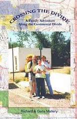
 here waiting for me. We went into Glacier at Two Medicine Campground to get my permit through the park. The Legend continues! I have heard so many stories about CDT hikers being hassled getting permitted through the park. I was in the office for an hour. They kept wanting twenty bucks for an advance reservation but I refused to pay it. What they should be offering CDT hikers that want to do long mileage is a 16 dollar permit beginning at Marias Pass to 2 Med, Red Eagle Lake, Swiftcurrent, Fifty Mtn., Waterton. That would cost half of the 32 dollar permit they wanted from me to do the same thing. I watched the video and they agreed to let Gaila pick up my permit and pay my 12 bucks. They said Fifty Mtn. might be filled by the next day so I gave them alternative campgrounds. I did 26 miles the next day, came in after the office was closed and found Gaila with a 16 dollar permit, going places I didn't want to go and in the park an extra day I wouldn't be there. I had to do 25 miles next day but decided to leave late in the morning and call the Superintendent. I was able to talk to the assistant Super, Butch Farabee. He was very nice. I wish I had been but I was a little hot. I asked him if this was some kind of game played on CDT hikers. He said he didn't know but would find out. CDT hikers are coming through the park early season and late. There should be no problem. He finally approved me through the park to hike where I wanted, camp where I wanted and if I had any problems with permit inspections have them call him. I made it to Red Eagle Lake. A Griz warning was posted but I never saw any sign of them. This is the most spectacular place in the world and the most inspiring place along the trail. I was floating off the trail knowing that I have made it and the weather was so fantastic. I made 29 miles the next day into Swiftcurrent where I had a shower and Gaila made me a roast beef dinner. The next morning I headed out with a backpack full of donuts. I spent the morning hiking with a couple from Kalispell and an hour at the Granite Park Chalet with a group with horses. I took my time and made it to Fifty Mtn. just before dark. This was the first time on the whole trip that I spent a night in a campsite with other people. I had a great time showing them my zip ztove and telling them about my adventure. I got up at dark thirty and made the 11 miles to Goat Haunt as Gaila was getting off the boat from Watertown. I talked for a half-hour with all the Scottish and English people in a tour group and then Gaila and I headed down the West side of the lake for the border. The weather was so wonderful I felt like turning around and heading back to Mexico. I hated to see the trip end but I was looking forward to a nice steak dinner in Watertown. This has been an incredible 3200 miles. It has been five months of meeting wonderful people and living in some of the most wonderous wilderness on the planet. Keep Smilin', Dick E. BirdYou can read the whole story, plus my Great Divide Trail hike in "Crossing the Divide" available at Mallerybooks.com